
The Magnetic Island Walking Trail Network
Stretching over 25km, these interconnected walking tracks and trails travel through protective parks and council land, ensuring a seamless journey. The network offers a remarkable opportunity to explore the island's captivating landscapes and enchanting villages. As you traverse these routes, you'll have the chance to reconnect with nature, meandering through valleys and ascending over majestic mountains. Embrace the beauty of Magnetic Island from a unique perspective as you immerse yourself in its natural wonders along these picturesque walking trails.


LOOKOUTS

WATERFALLS
Grade: Moderate
Duration: 4km return / 1.5hrs
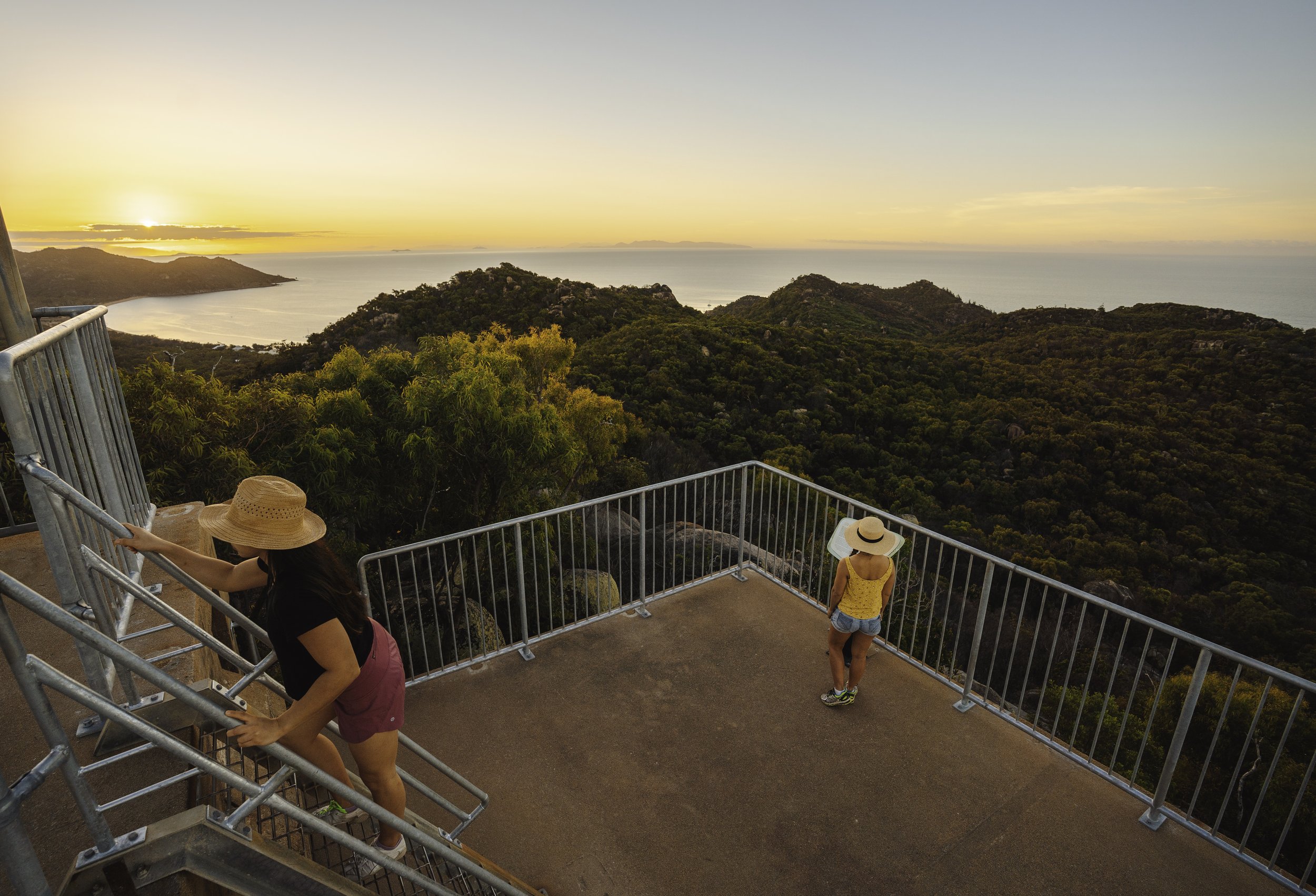
THE FORTS WALK
One of the most renowned walks on Magnetic Island offers a truly enchanting experience, providing visitors with breathtaking 360-degree vistas of the coastline and the Coral Sea. The journey begins at The Forts Junction, located between Arcadia and Horseshoe Bay and easily reached via bus, bike, or vehicle. The Junction offers an interactive and educational experience for families to learn about the local animals and plants. The trail follows a ridge behind some of the islands most picturesque bays treating hikers to captivating views before reaching the fascinating ruins of the Forts complex, which served as an operational site during World War II. These historical remnants, listed on the Queensland Heritage Register, stand as remarkable examples of fortifications found along Queensland's east coast. From the lookouts at the Forts, visitors can relish in magnificent panoramic views that stretch northward to the Palm Island Group and southward to Bowling Green Bay National Park. Notably, this particular walk is renowned for its opportunities to spot koalas in their natural habitat. Magnetic Island is home to the world's largest free-roaming koala colony, and lucky hikers often encounter these adorable creatures nestled among the island's trees. The combination of stunning vistas, historical significance, and the chance to observe koalas in the wild makes this walk a truly unforgettable experience for all who venture upon it.
Grade: Moderate
Duration: 3.2km return / 1hr
THE FORTS TO FLORENCE
The Wumbu track was opened in 2023, leading straight from the top of the Forts Circuit to Florence Bay; the track is clearly signed and leads you to the idyllic Florence Bay, a popular beach for swimming and snorkeling. Casuarina trees line the beach, providing the perfect shade for a siesta from life worries.
Following the Radical Bay Road will lead you towards Arthur Bay, where you can reconnect with the Forts Junction. Alternatively, you can choose to journey towards Radical and Balding Bay, culminating at Horseshoe Bay. Another possibility is to conclude your adventure by completing the Wumbu loop, ascending to rejoin the Forts Circuit. It's important to note that if you opt for the loop, the ascent is steep, with a considerable number of stairs.
Grade: Moderate
Duration: 3km one way
ARTHUR, FLORENCE, AND RADICAL
Starting at the Forts car park along Horseshoe Bay Road, a straightforward trail guides you to these untouched bays, each possessing exceptional qualities.
Arthur Bay is renowned for its fringing reef, offering opportunities to snorkel among marine creatures, a meandering tidal creek, and a picturesque sandy shoreline.
Florence Bay is a must-visit for snorkeling enthusiasts, showcasing striking coral bommies and the elusive Mermaid Cove.
Radical Bay invites you to enjoy ideal swimming conditions, witness the island's iconic palm trees, and admire its renowned rock formations.
Grade: Easy
Duration: 6km return / 2hr
Arthur Bay walk – 1.4km return (30 minutes)
Florence Bay walk – 3.6km return (1 hour)
Radical Bay walk – 6km return (2 hours)
HORSESHOE BAY LAGOON
Leading off the main road near Horseshoe Bay beach, a short track leads to the lagoon where you can see several waterbirds over the wetlands. There are two ways to enter the lagoon: from Horseshoe Bay Road, turn West onto Henry Lawson Street, at the end of the bitumen (you can park your vehicle here), pass through the gate, and continue along the dirt track, the entrance is marked by two small boulders, continue down the sandy track to the boardwalk. For wheelchair and pram accessibility, drive to Sandals Boulevard and continue straight through the estate before turning right onto Pandanus Drive. On the corner, you will see a concrete path leading into the trees, this connects to the boardwalk.
Grade: Easy
Duration: 200m return / 15 minutes
HORSESHOE TO BALDING AND RADICAL BAYS
Starting from the eastern end of Horseshoe Bay beach, the track embarks on a scenic journey that takes hikers through a steep gully adorned with lush forest vegetation. As they ascend, the trail opens up to a ridge characterized by expansive eucalypt woodlands. At this point, the track branches off, presenting two enticing options for exploration. One branch leads down to the tranquil and secluded Balding Bay, providing a serene and peaceful setting for relaxation. The other branch continues onward, leading to the picturesque Radical Bay. Both bays offer idyllic swimming opportunities, inviting visitors to cool off in the clear waters and soak up the natural beauty that surrounds them. To complete the loop, an unsealed road guides hikers back from Radical Bay, guiding them past the enchanting Arthur and Florence Bays before reconnecting with the main road at The Forts Junction.

ARCADIA TO HORSESHOE BAY
The Arcadia to Horseshoe Bay track opened in 2011. This walking track replaces the old walkway adjacent to the main road winding uphill to the saddle between Nelly and Horseshoe Bay, passing through native grasses, delicate wildflowers, and an impressive stand of grass trees. Continuing past the Sphinx lookout, the track veers off to the right at the ‘Forts Junction’ following the ridgeline before descending to the Radical Bay and the Forts Junction car park. Continue 2.1km via track and Horseshoe Bay Road to the beachfront.
Grade: Moderate
Duration: 3.2km return / 1hr
GABUL WAY
This elevated, scenic walkway is adjacent to Arcadia Road and is made up of two sections linking Nelly Bay and Geoffrey Bay. Gabul Way is suitable for walkers and cyclists and is disabled-compliant, with breakout platforms along the way to pause and enjoy the Island coastline and views across the bay.
Grade: Easy
Duration: 1.5km return / 0.5hr
PICNIC TO WEST POINT
This walk follows a bush track that links the bays on the western side of the island. The track passes a tidal wetland, mangroves, paperbark swamps and savanna grasslands. Flora and fauna are different in this area to the eastern side of the Island, making the journey particularly rewarding.
Grade: Easy
Duration: 16km return / 5hrs
NELLY BAY TO ARCADIA
Continuing along Mandalay Ave, Nelly Bay, this walk passes through a cool patch of rainforest alongside Gustav Creek, then climbs gradually to the saddle between Nelly and Horseshoe Bays. The track follows a ridge with views over Horseshoe Bay before it branches, with one track leading on to Horseshoe Bay, and the other down to Arcadia past the Sphinx lookout.
Grade: Moderate
Duration: 5km one way / 1.5hrs
HAWKINGS POINT
The Hawkings Point track is one of the easiest and shortest walks with an exceptional view. From Picnic Street in Picnic Bay (the police office end of the street), a track winds to the top of a fenced large boulder, affording a spectacular panorama over the island past Rocky Bay to Nelly Bay and Geoffrey Bay and back towards Townsville.
Grade: Easy
Duration: 1.2km return / 1hr